PRSAR Water Recovery Team
Peace River K9 Search & Rescue maintains a specialized unit for the recovery of a lost person in water. This unit consists of Highly trained K9, both Cadaver and Live find, a Sonar operator, Divers and a boat Captain all trained in Drowned Victim Recovery (DVR). All DVR K9 teams have Certifications from either NAPWDA, NNDDA or NASAR Type II Water meeting FEMA 508 and ASTM standards. The team is trained in 2D, Side imaging Sonar and Down Imaging technologies to complement the K9's in the boat. All team members pass a swimmers safety course and crime scene preservation.
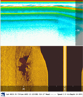
Peace River K9 Search & Rescue uses side scan sonar technology to locate underwater targets and perform sonar mapping. The sonar is also used to locate dangerous areas that the divers need to avoid for safety considerations. The use of this technology greatly speeds up the recovery.
Peace River K9 Search & Rescue uses side scan sonar technology to locate underwater targets and perform sonar mapping. The sonar is also used to locate dangerous areas that the divers need to avoid for safety considerations. The use of this technology greatly speeds up the recovery.