The Robotics Team
On many searchers the use of helicopters has been suspended due to factors such as maintenance, fuel, weather and the high cost of operations. The standard cost of operating a Jet Ranger Helicopter is around $2000 per hour. With the smaller budgets many departments cannot afford too much flight time. Add to this problem factors such as Topographic maps that are years old and Google Earth / GIS images which are not regularly updated. In States like Florida that have wet and dry seasons, a section that looks dry on the map may be several feet under water during the rainy season. What then is the SAR operation supposed to do in order to be effective and maintain the safety of its searchers?
In the spring of 2013, PRSAR began looking into the possibility of using remotely piloted vehicles (RPV) to complement Search & Rescue operations. These RPV's have the capability of sending both still shot mapping images as well as live video feed back to the base of Operations. This technology has proven to be quite valuable at being able to map areas ahead of searchers to look for catching features in the terrain where a lost person might seek refuge and identifying dangerous areas that searchers should avoid. Certain RPVs that can hover, have been stationed near trail heads to monitor for lost persons traveling through. The RPV can be tasked to patrol High probability dangerous areas during hasty searches to facilitate the rapid response of SAR teams.
Problems with Drone Imagery
With the vast amount of images that are produced during a search, it becomes impossible for the human eye to detect all the anomalies in a photo. This failure rate was confirmed in a study done in Canada. The source of the study referenced in the Problems Worth Solving Section, "A SAR study shows humans are only capable of spotting a target 30% of the time when reviewing digital images." is titled ‘Gaze Behavior of Spotters During an Air-to-Ground Search’ by James L. Croft, Daniel J. Pittman, and Charles (Chip) T. Scialfa, University of Calgary, Calgary, Alberta, Canada
It can be accessed at the following link: https://www.ncbi.nlm.nih.gov/pubmed/17702218
Knowing that there is a 70% failure rate for the human "squinter" in the image review process, it became clear that Image Recognition Software was needed. PRSAR began working with several software providers and is currently using an advanced image software and can scan images quickly that show the exact time and location of the anomaly along with a written report.
PRSAR Pilots have or are working to achieve their Part 107 Certifications through the FAA. They continuously train to keep mission-ready status and must demonstrate proficiency by evaluation under testing as set forth by ASTM/NIST. Click here for more information.
For a demonstration please contact us at [email protected]
Typical Mission that PRSAR RPV's will Fly-
1) Situational Awareness and Reconnaissance - This mission will produce a High resolution composite image or ortho-mosaic that is suitable for map making and/or Google Earth overlay to assist Search Managers by providing real time area conditions to identify hazardous areas and areas of interest.
2) Search Mission - Searching for either a missing person or person of interest with either Fixed wing or Rotor wing aircraft. These missions will produce both Video data and well as single image data that is then Geo-tagged and processed by PRSAR's proprietary image recognition software. Targets of interest are then sent to Command for search team tasking.
3) Flood Assessments - This mission is flown for Emergency managers who need real time video of flooding conditions in critical areas. Both Photo imagery or live video is possible and can be transmitted directly to the Emergency Operations Center.
4) Debris Estimation - Either fixed wing or rotor-craft can be used for this mission offering either Geo-tagged images or video for Disaster Managers to assign rescue and clean up assets and estimate clean up costs.
5) Structural Inspection - This mission uses a Rotor-craft with a remote pilot operator working with the Structural Engineer as to viewing angle requested and altitudes needed. For this mission both FLIR and Live video are available.
Currently PRSAR RPV is flying in accordance with the Operation and Certification of Small Unmanned Aircraft Systems, Title 14, Code of Federal Regulations, Part 107 as directed by the FAA. PRSAR pilots have their Part 107 certifications and all aircraft are registered and insured. PRSAR uses best practices as developed by NIST and ASTM.
PRSAR's Data Policy - PRSAR is NOT a repository for storing data from search efforts. Our storage space is limited. We will turn over all images to the Agency Having Jurisdiction at the time of the search and keep a copy of those files for 30 days at which time the files will be deleted.
Water robotics
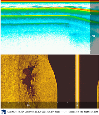
The Water Robotics unit works hard to be able to map and detect targets under the water. All of the PRSAR watercraft have side can and down-imaging equipment. Peace River K9 Search & Rescue uses side scan sonar technology to locate underwater targets and perform sonar mapping. The sonar is also used to locate dangerous areas that the divers need to avoid for safety considerations. The use of this technology greatly speeds up the recovery.
One of the products that the team can produce is the Side Scan mosaic. Side scan mosaic is the overlaying of side scan data from a sonar log onto the map view. The process involves removing the water column from the raw sonar return and locating the remaining sonar image in the correct geographic location. The result of this process is a highly detailed two dimensional map image showing underwater structure and features. This overlay can be exported into a .KMZ file for overlaying on Google Earth and GIS maps.
One of the products that the team can produce is the Side Scan mosaic. Side scan mosaic is the overlaying of side scan data from a sonar log onto the map view. The process involves removing the water column from the raw sonar return and locating the remaining sonar image in the correct geographic location. The result of this process is a highly detailed two dimensional map image showing underwater structure and features. This overlay can be exported into a .KMZ file for overlaying on Google Earth and GIS maps.